Winter Storms With Record Heat, What’s Wrong With This Picture?

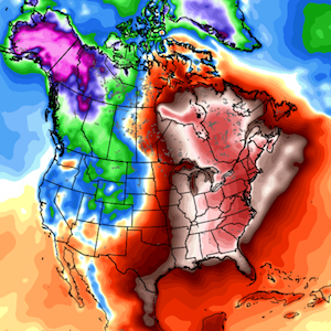
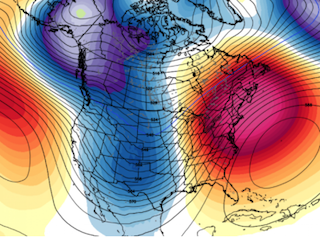
Dane Wigington geoengineeringwatch.org As strong plumes of moisture flow in off of the record warm Pacific ocean, heavy aerosol spraying of chemical ice nucleating materials begin the cool-down that is paving the way for "winter storm Ferus", the latest creation from the climate engineering cabal. The combination satellite radar image below reveals the flow of Pacific moisture over the Western US. It also reveals the extremely long plume of moisture and aerosolized cloud cover spanning from far out into the Eastern Pacific, all the way to Greenland. The brighter the white of the cloud cover, the more aerosolized it is. The composition of the ever expanding aerosolized cloud canopies are very different than natural cloud formations. Some "streaking" can be seen on the image above from the constant aerosol dispersions. The aerosolization/chemical nucleation process (causing an endothermic reaction) dries up much of the moisture and scatters it over a much broader area. What is the result? A "winter snow storm" from a flow of moisture that originated over record warm ocean temperatures of the Pacific. The climate engineers are looking for "winter" headlines to counter the current record warmth in the Eastern US, down under in Australia, and even unprecedented winter forest fires in places like Spain. Record forest fires are now occurring during all seasons and all over the planet. Click HERE for a photo gallery of the fires in Spain. In spite of all the global hot spots, (and the increasingly rapid overall planetary warming), the climate engineers are throwing everything they can at "winter storm Ferus". Naming the engineered "winter storms" dramatizes the headlines, the desired effect for the geoengineers and the power structure controlled Weather Channel. Does the scenario in the NOAA map below look in any way "normal"? The current scenario is the exact antithesis of the previous three winters in the US, it is completely engineered. The geoengineers are becoming increasingly blatant and desperate as the unraveling of the climate system continues to pick up momentum. A record warm Christmas is likely in the very locations that had record cold and record snow only last year. How warm will it likely be in the Eastern US? The air temperature map below should be a wake up call. The actual temperatures are likely to be even higher than the "official" forecasts and the "official" daily high readings reported. Underreporting of temperature readings is now becoming the norm as the power structure desperately tries to hide the full gravity of what is unfolding around us all (while making the situation even worse at the same time). What are the long term global temperature trends? Multiple record graphing sources and an endless flow of frontline data paint a clear picture. Though the flow of disinformation in regard to the true state of the climate is epidemic, people must learn to look behind the headlines and the sources used to make them. Frontline data is the bottom line, those who truly want to get at the truth will take the time to examine such data. The rate of planetary warming is beyond dire, geoengineering is making the situation far worse, not better. Thousands of high temperature records have been set in the US during the last two weeks, many more will fall before the end of 2015. This will be the warmest year on record with temperatures shattering the former record set only last year. 2016 will likely break the record yet again. Even the world's lakes are heating and dying. Massive methane releases may have already pushed the planet into a runaway greenhouse event, climate engineering has also exacerbated the overall methane scenario. It is imperative for populations to wake up and realize the immediacy of the challenge we face. The equation could not be more "non-linear". Though there are countless sources of anthropogenic activity decimating the planet and the climate system, global geoengineering is at the top of the list. The extreme temperature imbalances and climate engineering contamination fallout are wreaking havoc on the biosphere and all life. The temperature extremes reflected in the map above are unprecedented. The extreme heating of ever larger regions is beyond alarming. Many areas of Eastern North America are likely to be as much as 30 degrees above normal by Christmas eve. The planet's ability to support life is rapidly slipping away, what will you do? What will all of us do? Our challenges are many, but exposing and halting climate engineering should be, must be, our top priority. Make your voice heard by passing on credible information to all those around you, to all those that will listen. It is up to all of us to make every day count in this most critical battle. DW May be freely reprinted, so long as the text is unaltered, all hyperlinks are left intact, and credit for the article is prominently given to geoengineeringwatch.org and the article’s author with a hyperlink back to the original story.
More exceptional warmth on the way for the Eastern U.S. during Christmas week

Source: Washington Post The upper air weather pattern is expected to turn abnormally warm again around Christmas. (weatherbell.com) The Eastern United States is just coming off a December “heat wave” . But don’t get too comfortable in your winter coats — another warm-up is expected to peak in the days around Christmas, and it, too, has the potential to topple records. In the short-term, temperatures across the Eastern United States are forecast to dip to around average over the weekend (December 19-20), and in some places a few degrees below average. The Gulf Coast and Florida will see the “coolest” temperatures of the weekend — 10 to 15 degrees below average for this time in December. But this cool pattern will not last. The (brief) cool-down coming this weekend for the Eastern U.S. (weatherbell.com) Starting Monday, forecast models are predicting the pattern will flip back to what we’ve become so accustomed to this month: a warmer than average East and a cooler than average West. [The calendar says December but these flowers could not care less] “Storm systems are forecast to track towards the Great Lakes region,” said Wes Junker, the Capital Weather Gang’s winter weather expert. “Because the flow around storms is counterclockwise, the deep southerly flow to the east of the storms will deliver warm air with southern origins.” This is the same configuration that delivered record-breaking high temperatures to much of the Eastern United States over the weekend. Temperatures were running 20 to even 30 degrees above average between Friday and Monday. According to the National Climate Data Center, a whopping 1,426 record high temperatures have been broken or tied so far this month, over half of which occurred between Friday and Monday. [November was warmest such month on record by a huge margin] The timing of the next warm-up seems to coincide with the days leading up to and around Christmas. The forecast models are in exceptional agreement that temperatures will run 15 to 20 degrees above average — and in some places closer to 30 degrees above average — starting Dec. 23. Temps will continue to run above average in the days after Christmas, just less so. In fact, models are not predicting this warm pattern to really give way until after the month is over. (NOAA) Given the agreement among models — and added certainty with a very strong El Nino continuing in the Pacific — NOAA’s Climate Prediction Center is forecasting a 90 percent chance that temperatures will be above average in the second to last week of December, with “above average” chances that the warmth will continue through the first week of January. [The December full moon falls on Christmas for the firs time in 38 years] While models were homing in on the Midwest for exceptional warmth in the first half of December, the Mid-Atlantic and Northeast appear to be the targets for the last two weeks of December. Temperatures in the Mid-Atlantic have already been running well above average this month, and the final warm punch could break records for warmest December. 70s on Christmas Eve? It’s possible. (tropicaltidbits.com) “Temperatures could again flirt with records in some locations unless clouds and or fog help to hold them down,” Junker said. Forecast highs in New York City are in the mid to upper 60s in the days around Christmas. In Raleigh, N.C., highs in the mid-70s are possible. At Reagan National Airport, D.C.’s official climate monitoring station, the average temperature through Dec. 14 was 50 degrees, more than eight degrees above average. The record warmest December was 45.6 degrees, which was tied between 1889 and 1984, this month will challenge that record thanks to the very warm head-start and the potentially extreme temperature rebound next week. Temperatures are forecast to run up to 30 degrees above average on Dec. 24 and 25, shown here in degrees Celsius. (weatherbell.com) Source: Washington Post
